Super Storm for the Southern Tier
Looking outside the Hawk studios in Downtown Binghamton as I'm writing this, it doesn't look like much right now, but the latest weather map from the National Weather Service is calling for the Southern Tier's first big snow fall of 2015. Watch it if you are planning to go out Sunday night for that party or for your Monday morning commute. Glenn & Traci will have any school closings or delays Monday morning on the Hawk Morning Show and on line at 981TheHawk.com.
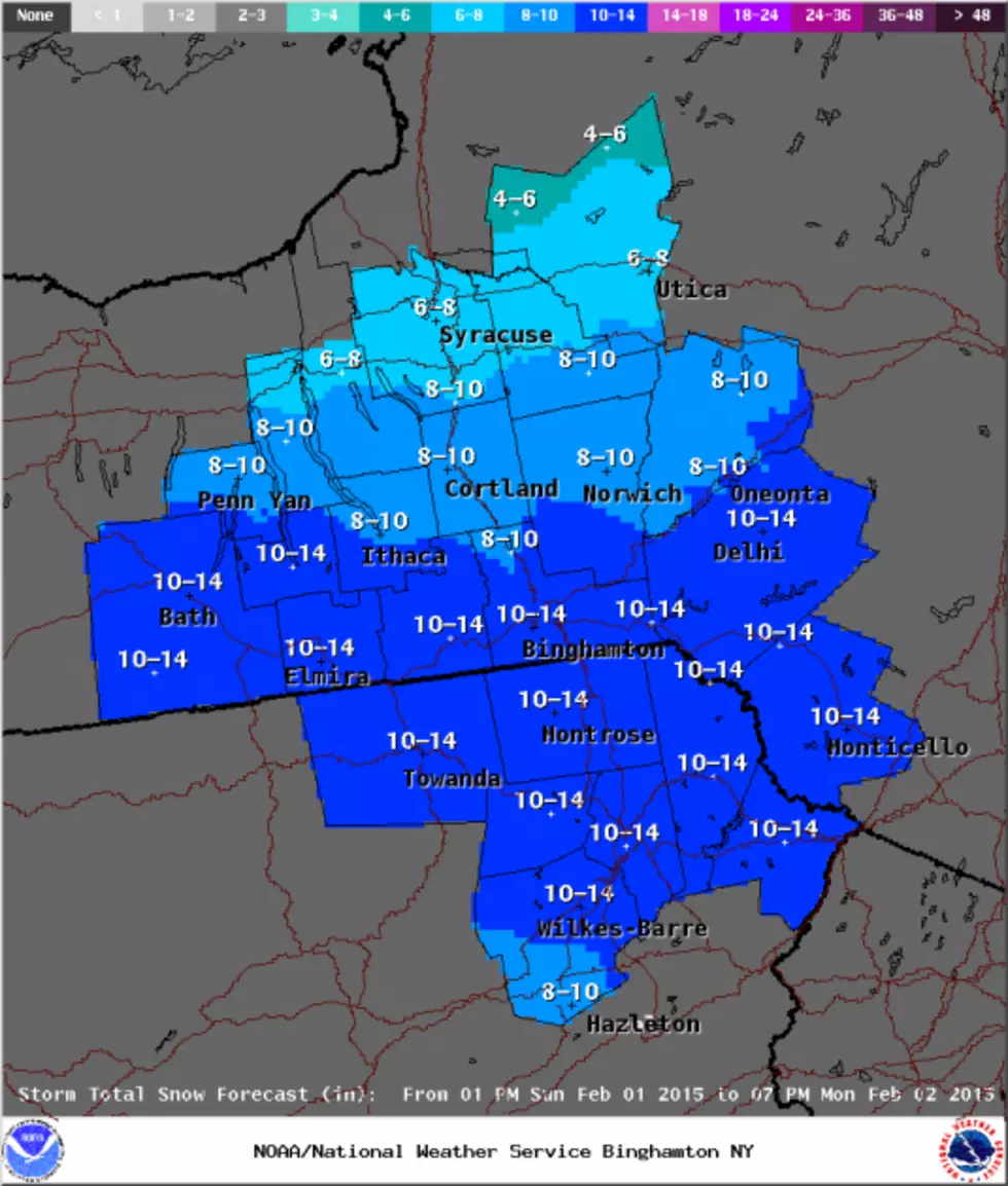
A Winter Storm Warning is in effect for all counties Sunday afternoon through Monday afternoon
Significant area wide snowfall Sunday evening through Monday afternoon is likely. Please monitor the forecast.
Here's what WBNG Storm Tracker Weather is saying:
An intensifying storm system approaching from the Ohio River Valley will become well developed off the east coast tonight and Monday. During this process, I expect to see steady snow overspread the Tiers this afternoon.
The Timing:
-Sunday Night after 8PM: Snow, heavy at times with rates of 1-2"/ hour possible into Monday morning. 4-8" Sunday night.
-Monday: Steady snow tapers to snow showers during the afternoon and evening hours. An addition 3-7" possible.
We anticipate all snow throughout the event; however there are some indications of perhaps a period when we mix with sleet Sunday night, especially south of Binghamton. Our current thinking is this will remain near Scranton points south. However, if the storm tracks further north, that mix line may get closer to our region and if we do mix with sleet, then our snowfall forecast will have to be reduced. Nonetheless, if we remain all snow, a general 6-12" snowfall is probable with isolated higher amounts by Monday evening.
Impacts to consider after the football game ends Sunday night:
-Snow covered roadways
-Reduced visibilities
The storm begins to rapidly intensify to our east later Monday. At this point, we are on the back side of the storm with a northerly wind. Very cold Arctic air will filter into the Tiers Monday night. Temperatures are expected to fall below zero Tuesday morning with an even colder windchill in the teens below zero.
Another weak storm system will approach from the west Wednesday into Thursday. This will provide our area with a light snowfall as we may pick up an additional 1-3" by Thursday morning.
Thursday will be breezy as winds come from the north. Very cold, near record breaking Arctic air will return back into the Tiers Thursday night. Temperatures are expected to drop well below zero, averaging anywhere from 15 to 5 BELOW zero, with a wind chill in the 20s to perhaps 30 below zero.
Partly cloudy and cold conditions for Friday. A cold front approaches the Tiers on Saturday and this will bring another chance for scattered snow showers.
For the latest satellite weather maps click HERE
More From 98.1 The Hawk